California Is Over That Hill, Eventually

California Hill, near modern-day Brule, Neb., is where many westward settlers encountered their first large climb from the Platte River valley to higher terrain. (Photo by Michael E. Grass)

California Hill, near modern-day Brule, Neb., is where many westward settlers encountered their first large climb from the Platte River valley to higher terrain. (Photo by Michael E. Grass)

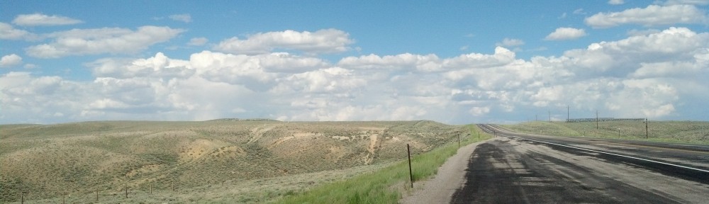
BRULE, Neb. — It may not look like much, but the beautifully rolling topography wedged between the Platte River’s north and south forks was one of the first big endurance tests for any westward-bound emigrant.

California Hill is located near Brule, Neb. (Photo bu Michael E. Grass)

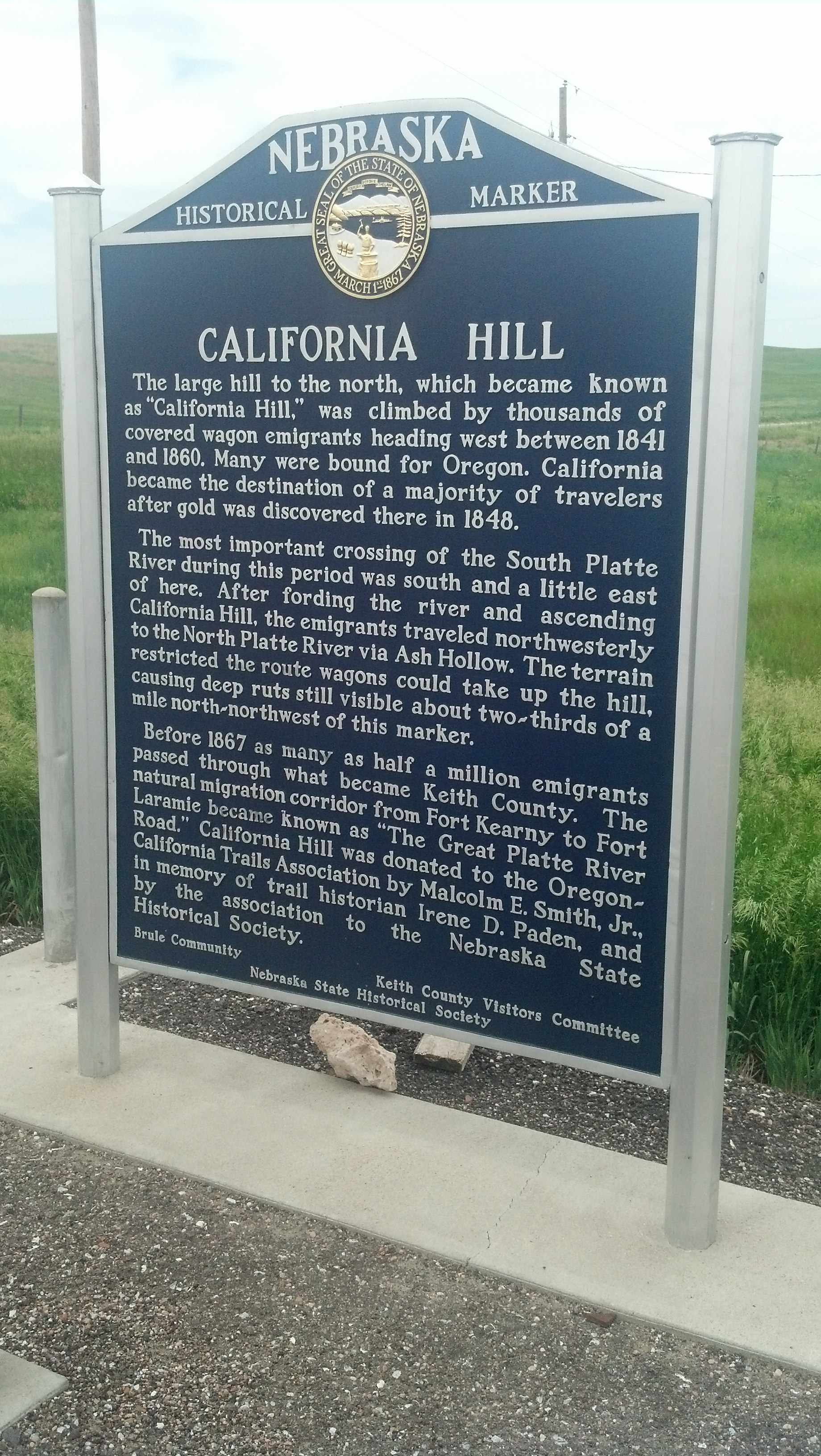
California Hill is located near Brule, Neb. (Photo by Michael E. Grass)

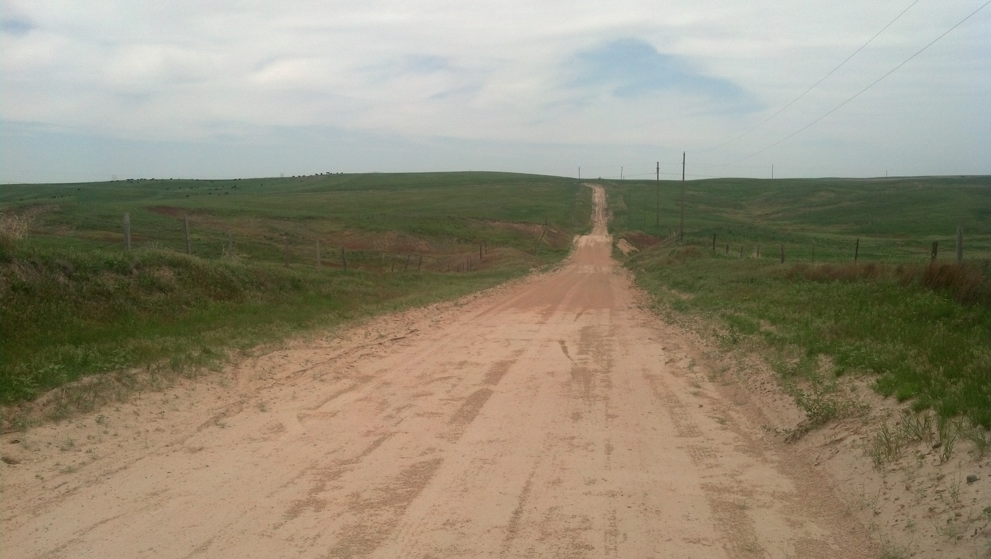
This is California Hill, the place where thousands of wagons carrying settlers and supplies bound for California, Oregon and other points westward encountered their first major uphill climb. There certainly aren’t any major mountains here, but as central Nebraska pushes into western Nebraska, a gradual change in topography is noticeable. In this case, a big hill is still a big hill, especially when the previous few hundred miles have been absolutely flat.

Most westward emigrants heading through Nebraska would stick to the south side of the Platte River. (Many Mormons traveled along the north side of the river.) Near modern-day North Platte, the city that’s home to the Buffalo Bill Ranch, the river forks into two branches: The South Platte continues to the southwest into northeastern Colorado and onward to Denver while the North Platte continues in a northwesterly direction toward east-central Wyoming and, eventually, South Pass, the all-important crossing of the Rocky Mountains.

At California Crossing, emigrants would ford the South Platte, trudge up California Hill toward the north and northwest and later connect with the North Platte. This territory is apparently full of old emigrant wagon ruts.

I was on the lookout for these remainders from the former overland trails, but couldn’t pinpoint any within view of the dirt road I drove up from U.S. 30 to reach this beautiful and peaceful windblown spot.

Post continues below …

2013-06-14 14.15.10

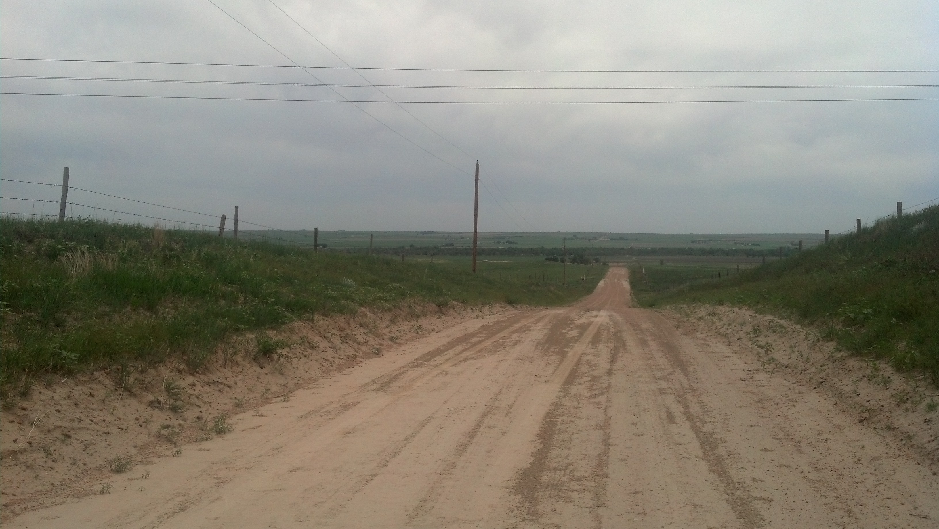
Looking from California Hill down toward the South Platte River. (Photo by Michael E. Grass)

For his 2001 book Wither Thou Goest, author Patrick Simpson visited California Hill as part of his journey following his ancestors’ 1878 trek westward. He had some trouble at California Hill, just like me:

Continue reading

Seeing Rural Nebraska’s Great Demographic Shift

The L.R. Ranch motel greets travelers on U.S. 30 heading into Lexington, Neb. (Photo by Michael E. Grass)

The L.R. Ranch motel greets travelers on U.S. 30 heading into Lexington, Neb. (Photo by Michael E. Grass)

LEXINGTON, Neb. — The approach to this city 11 miles west of Overton is just like most other settled spots along the Union Pacific Railroad and the Lincoln Highway. Railroad tracks? Check. Grain elevator? Check. Town grid starts north of the highway? Check, check, check, complete with the aging L.H. Motel and its faded sign declaring “Quality for Less.” (Since I was just passing through, I couldn’t confirm the accuracy of that claim.)

Washington Street is one of Lexington, Neb.'s principal commercial streets. (Photo by Michael E. Grass)

Washington Street is one of Lexington, Neb.’s principal commercial streets. (Photo by Michael E. Grass)

Since Lexington stands out as a somewhat larger town than most along Nebraska’s stretch of the Lincoln Highway — the 2010 Census found 10,230 people living here — the town’s main commercial area stretches a little bit farther north from U.S. 30.

Heading north on Washington Street, this could be any town’s main street, lined with one- and two-story commercial buildings.

It looks ordinary. But look closer. It’s in Lexington where you really start to grasp just how diverse some rural Nebraska communities can be.

Continue reading

Patterns in the Platte River Valley

Looking toward U.S. 30, a grain elevator towers over Overton, Neb. (Photo by Michael E. Grass)

Looking toward U.S. 30, a grain elevator towers over Overton, Neb. (Photo by Michael E. Grass)

OVERTON, Neb. — While no two towns are exactly alike, there’s something of a pattern that the chain of human settlement in the Platte River valley follows. Long-haul travelers on Interstate 80 will miss this, but those following U.S. 30 will likely pick up on the template for these towns along the way.

Heading out of any city, town or Census-designated place along U.S. 30, and off in the distance, a tower will rise out of the alignment of the road a few miles down the highway.

A few minutes later, cruising alongside the Union Pacific Railroad tracks and through the flat countryside, the outline of the next town will come into view. Heading west, the tracks are on the left and the town is on the right, just north of the highway. Between the highway and the Union Pacific tracks is the tall grain elevator standing amid a cluster of warehouses and other support buildings.

The town’s street grid will start at the highway and assuming it’s a small place — and most of them are — it will spread out for a few blocks before the flat farmland reappears.

This pattern will repeat itself every few miles, though the positions of the highway, railroad and grain elevator may shift depending on town.

It’s hard to miss the Platte River valley’s chain of grain elevators, which stand in succession along the Union Pacific like the Great Wall’s beacon towers. After awhile, this repetition will play out town and after town.

Overton, with a population of just under 600 people, generally fits this Platte River pattern, but its history doesn’t.

Continue reading

No, I Didn’t Use Gunpowder to Season My Chinese Food

KEARNEY, Neb. — After a few days of on-the-road food, I was desperate for something different — and hopefully healthier. Along the way, I’ve been doing my best with dried fruit, mixed nuts and water in an effort to try not turn into a roadtrip pig. But I’ve had my fair share of fast food, too.

By the time I arrived in Kearney, I was exhausted. The drive from Cedar Rapids, Iowa, with all of my stops, took me longer than I had planned for. I was thinking about checking out one of the downtown brewpubs, either Cunningham’s Journal or Thunderhead Brewing Company, but I wasn’t up for beer and when I drove by, they were packed.

The menu at Hunan Chinese in Kearney, Neb.

The menu at Hunan Chinese in Kearney, Neb.

Yelp pointed me to Hunan Chinese, which reviewers had indicated was “[h]onestly, probably the best Chinese in a 100 mile radius” and when considering all of the local restaurant offerings is “[a]s good as it gets for Kearney.” It wasn’t downtown but it was close to my hotel. And some Chinese food sounded good at the moment.

I have a soft spot for Chinese restaurants in the United States. I used to work at a fairly Spartan-looking Chinese take-out operation in high school. Over many generations, Chinese restaurants in the United States have become a critically important part of the American culinary footprint. The first Chinese restaurants in the U.S. opened during the California Gold Rush in mining towns — “Caucasian miners feared, ridiculed and discriminated against the Chinese, but loved their food,” according to the Sacramento Bee — but overtime, spread east, to places just like Kearney.

“What began in this country as exotic has become thoroughly American,” The New York Times wrote in 2004.

Recently, I’ve been seeking out more and more traditional Chinese cooking on my travels and when I can Sichuan food in particular. This has included some knock-out dishes at Han Dynasty in Philadelphia and great meals in Penang, Malaysia, where Chinese merchants brought their cooking traditions to the British outpost at George Town. I also recently ventured to Fredericksburg, Va., about an hour from Washington, D.C., to sample the cooking of acclaimed former Chinese Embassy chef Peter Chang. The chef has a bit of a cult following and has a somewhat mysterious track record of disappearing and reappearing in a random city with a new restaurant located in a seemingly nondescript strip mall. Chang has bigger plans for bringing his food to larger audiences.

Perhaps, Chang’s cooking will appear here in Kearney someday. In the meantime at Hunan Chinese, I knew I would likely be getting standard Americanized Chinese favorites, but that was OK. My stomach wanted some crab rangoon.

Continue reading

Kearney Is in the Middle of Somewhere

Central Avenue in Kearney, Neb. (Photo by Michael E. Grass)

Central Avenue in Kearney, Neb. (Photo by Michael E. Grass)

KEARNEY, Neb. — When the Lincoln Highway was routed through this city near the southern bend of the Platte River, a local farmer put up a sign trumpeting the fact that Kearney was 1,733 miles to Boston and 1,733 miles to “Frisco.” While the Lincoln Highway doesn’t go to Boston, that didn’t matter: Kearney was the “Midway City.”

It’s in the middle of somewhere, for sure. The U.S. Army established a rudimentary fort here in 1848 to help protect westward settlers passing through the Platte River valley. Fort Kearny (note the difference in spelling, the result of an error on an official application) was ideally situated because various trails from the east converged here to follow the Platte westward. The future transcontinental railroad would come through town, too.

Driving along Central Avenue, the broad brick-lined main commercial street, it’s hard to not to get the feeling that back in the day, Kearney had big dreams of being a major metropolis. The streets are wide — almost too wide — and the grid is quite extensive compared to most Platte River Valley towns along the Union Pacific Railroad and Lincoln Highway. Overall, there’s a slight emptiness to the city’s expansive scale.

In its first few decades, Kearney quickly grew into a boom town.

Continue reading

The Great Platte River Road Begins

The Great Platte River Road carried countless westward settlers across the Great Plains and into the Rocky Mountains. (Photo by Michael E. Grass)

The Great Platte River Road carried countless westward settlers across the Great Plains and into the Rocky Mountains. (Photo by Michael E. Grass)

FREMONT, Neb. — Of the most important waterways in the United States, the Platte River usually doesn’t rise to the top. Unlike the Mississippi and Missouri, it’s extremely shallow.

Washington Irving called the Platte “the most magnificent and useless of rivers.” But the Platte, called “Nebraska” by Native Americans, helped change the shape of American history. This route allows a relatively easy path into the interior.

The Great Platte River Road was used by countless settlers heading west to Oregon, California and Utah. The Union Pacific Railroad’s Overland Route follows the Platte westward along what was the nation’s first transcontinental rail link.

With a level route into the interior, it made sense to have the Lincoln Highway follow the Platte west as well. From Iowa, the original alignment of the highway takes the road into Council Bluffs, Iowa, and Omaha, Neb. But U.S. 30 makes a beeline from from Iowa’s Loess Hills to Fremont via Blair, Neb. Since I was continuing onto Kearney that day, I opted for the more-direct route.

Crossing the Missouri River adjacent to the Fort Calhoun nuclear power station — which was sidelined in 2011 after severe flooding along the Missouri River — U.S. 30 climbs from the valley to higher terrain on its way to Fremont.

Continue reading