The Bonneville Salt Flats near Wendover, Utah (Photo by Michael E. Grass)
WENDOVER, Utah — Leaving Salt Lake City on Interstate 80 heading deep into the desert, I wasn’t quite sure what to expect. As a child, I used to pore over my well-worn Rand McNally road atlases and was always curious about this part of the United States.
There were few labeled locations. And while there were some named mountain ranges, these maps lacked any detail pertaining to the true nature of the terrain, leaving me to imagine what was out here. National Geographic maps, naturally, were generally better at providing topographical detail, but they too couldn’t be a substitute for actually being there in person.
In the Rand McNally atlases, the course of the red-, blue- and black-colored roads gave some clue of the shape of the landscape. The more twists and turns in a road generally meant more difficult terrain to traverse.
The more straight sections signaled some sort of valley or relatively flat plain, but that’s not always indicative. Most roads in Iowa, for instance, are straight but they can cross some surprisingly hilly, undulating territory as I discovered earlier during my travels along the Lincoln Highway.
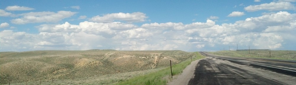
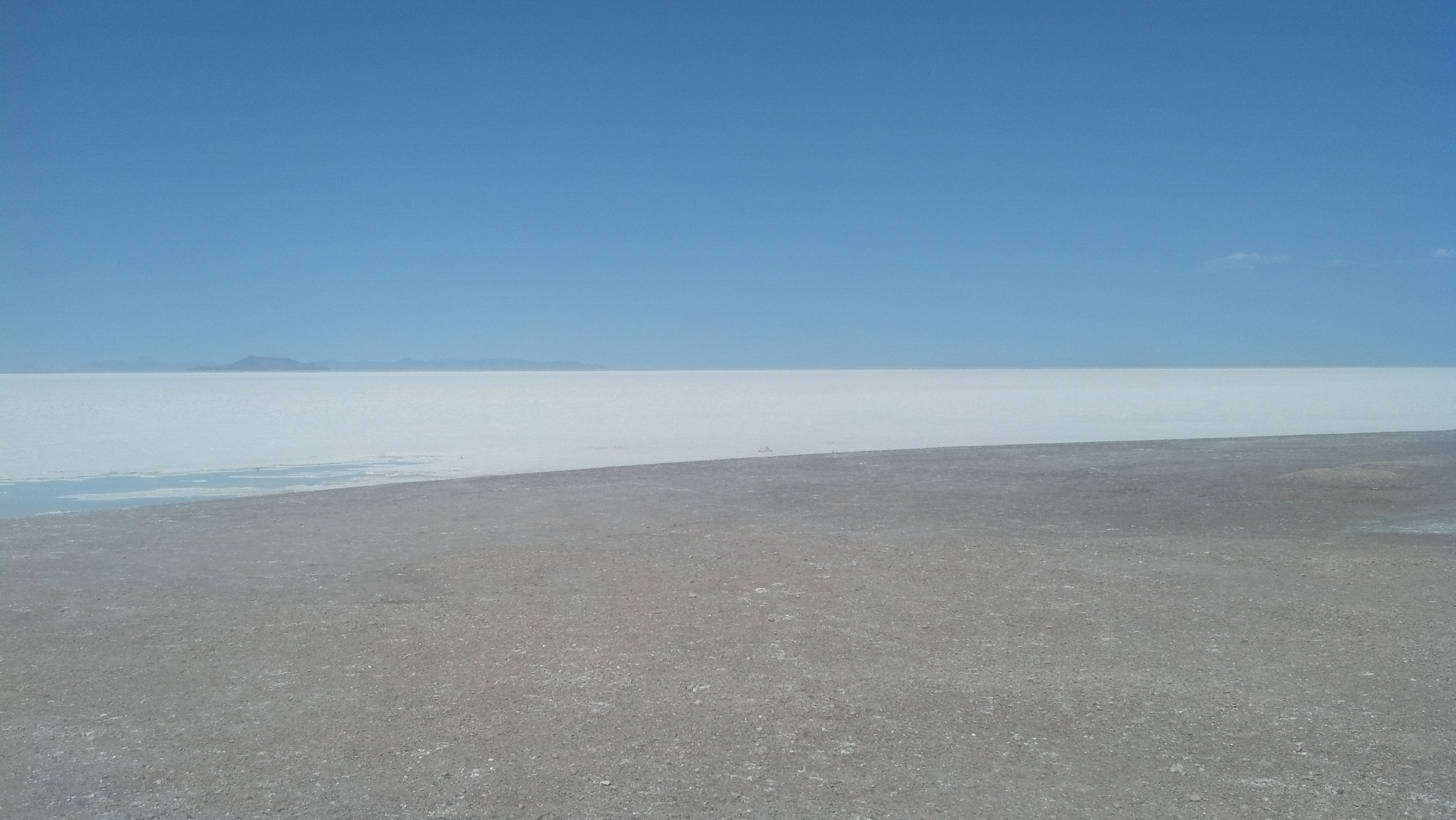
Western Utah is the physical manifestation of emptiness. (Photo by Michael E. Grass)
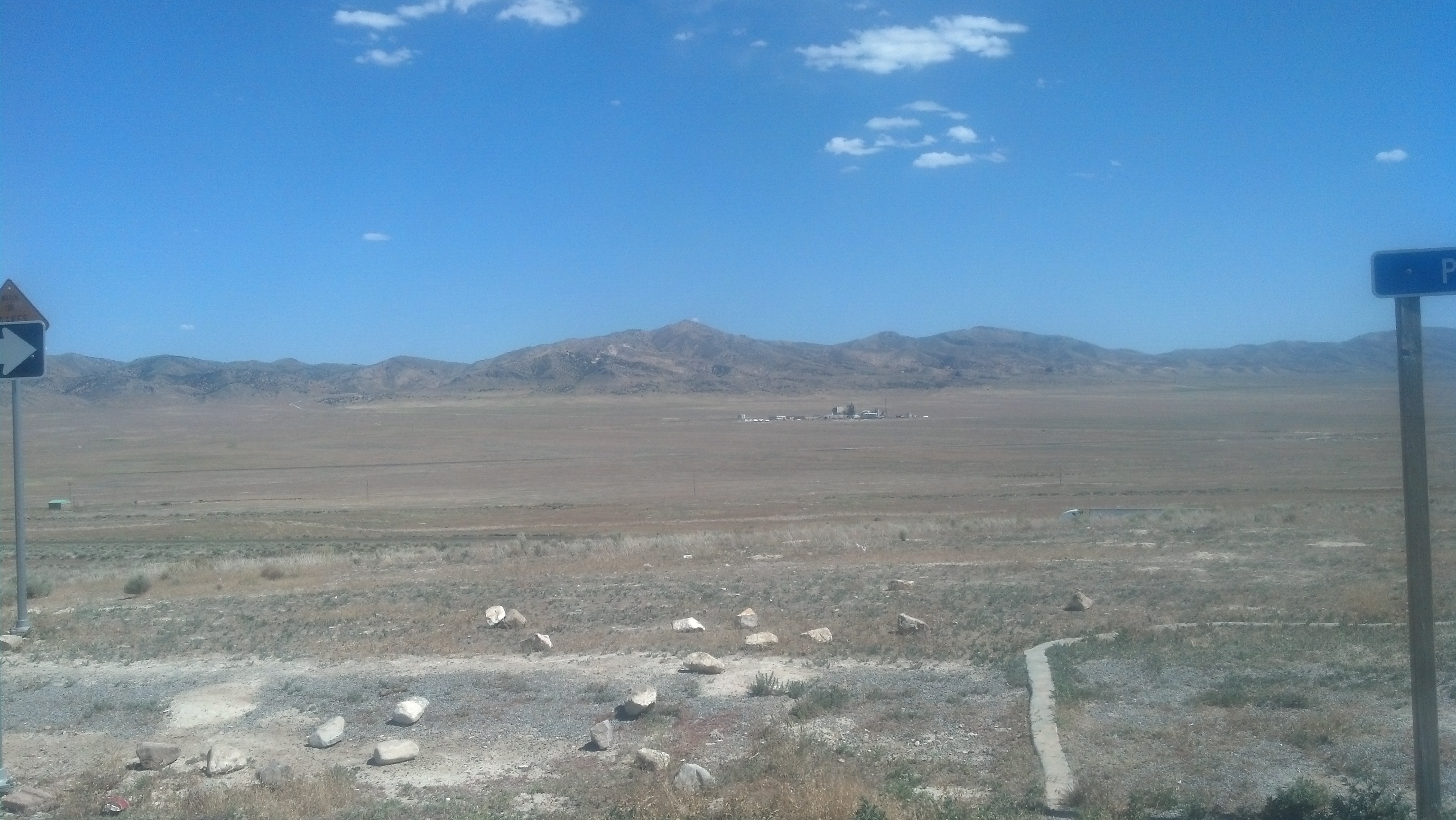
Looking at the road atlas in my youth, I-80 between one point west of the Great Salt Lake and the Nevada border was completely straight for roughly 45 miles. In the 120 miles between Salt Lake City and the state line, the atlas showed little evidence of any human settlement along I-80.
Places like this naturally spark curiosity. Who in their right mind would venture out here? For most travelers, this has been a place to quickly travel across and not linger for fear the forces of the desert will somehow eat you up or rob you of life-sustaining water.
Although I’ve been in the American Southwest on previous visits, the only comparative drive of complete and utter desolation I’ve had was crossing the Mojave Desert on Interstate 15 between Los Angeles and Las Vegas on a roadtrip in August 2001. And that stretch was driven at night when the darkness hid the landscape.
My rental car had been running great the entire trip along the Lincoln Highway, so I had little fear of getting stranded out in the middle of nowhere. Still, I stocked up on bottled water and some snacks, just in case.
For those trying to follow the Lincoln Highway itself, Utah presents some challenges. A century ago when the path of the highway was being settled, the route west of Salt Lake City was quite controversial. There were no roads out in this wasteland and the highway could potentially follow three general routes.
Lincoln Highway Association officials had advocated a more southerly route via Ibapah and Fish Springs along the former path of the Pony Express, which avoided the worst of the desert and the salt flats. But officials in Utah, apparently aligned with interests in San Francisco, thought that choice would inevitably steer cross-country travelers to a junction in Nevada that would tempt motorists to drive on toward Los Angeles along the Midland Trail.
The Utah officials wanted a route due west from Salt Lake City or north of the Great Salt Lake. The history of the Lincoln Highway here is extremely tortured, so I’ll spare you the minute details, but it is critically important to understand just how difficult a desert crossing was for early motorists.
Before I set out for the unknown in western Utah, I read about the challenges this foreboding landscape presented to the first transcontinental motor train as documented by Pete Davies in American Road:
The trouble began as they dropped into Skull Valley. The last six miles were on a desert trail that was two feet deep in places with alkali dust and fine sand. There had been no rain for eighteen weeks; it was like trying to drive in talcum powder. The trucks sank into the dust until their undersides grounded on the earth, their wheels spinning to no purpose in tractionless grit.
Although I sure the roads had been improved since those early days, I didn’t want to get stuck in something described as “tractionless grit.”
A friend back in Washington, D.C., had texted me when I set out on my journey and mentioned something that sounded like Skull Valley:
If memory serves me correctly, a couple buddies of mine and I got terribly lost in Utah and would up on the Lincoln Highway when we accidentally veered off the highway out of Salt Lake City. There was a diner near some army proving grounds. Skull Road or something.
Lincoln Highway enthusiasts enjoy exploring the first- and second-generation alignments through this empty territory, but sections are closed to the general public as they cross the U.S. Army’s Dugway Proving Grounds.
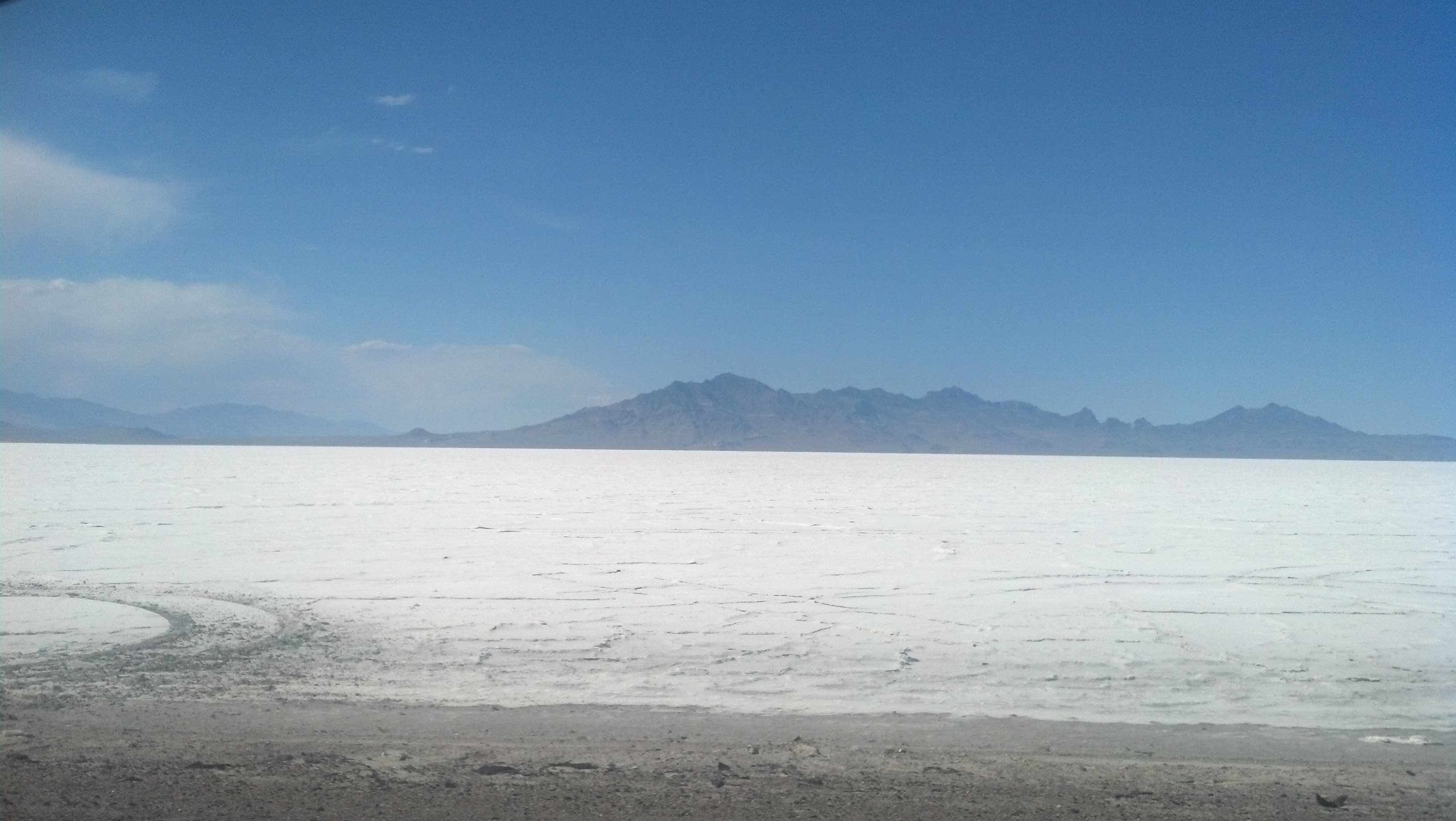
I decided to stick to I-80, which follows the route of the third-generation Lincoln Highway, according to the Lincoln Highway Association’s official map. In any regard, I wanted to see the Bonneville Salt Flats, the main attraction out this way.
***
When I was young on excursions to Lake Michigan, I was always fascinated by the summertime phenomenon of the highway pavement ahead disappearing into water vapor, which would subsequently disappear. The drive west along Lake Michigan Drive from Grand Rapids, Mich., to the beach on these childhood trips was very straight, much like I-80 out to Wendover. Driving toward the Nevada state line, I saw this mirage effect for the first time in a long, long time.
I thought this phenomenon would have a more complex name, but it’s technically just a mirage.
According to the Physics Stack Exchange forum, which has a handy illustration of how this all works:
The responsible effect is the dependence of the refractive index of air on the density of air, which, in turn, depends on the temperature of the air (hot air being less dense than cold air).
A non-constant density leads to refraction of light. If there’s a continuous gradient in the density, you get a bent curve (i) as opposed to light coming straight at you (d). Your eye does not know, of course, that the light (i) coming at it was bent, so your eye/brain continues the incoming light in a straight line (v).
And then I encountered another phenomenon while driving across what Davies described as “white furnace” territory in American Road. Off on either side of the highway, I spotted slender, towering swirls of desert dust whipping their way across the flat white expanse. I scanned the horizon and I counted a few more of these dust devils. One had even crossed the highway a mile or two ahead of me.
Post continues below …
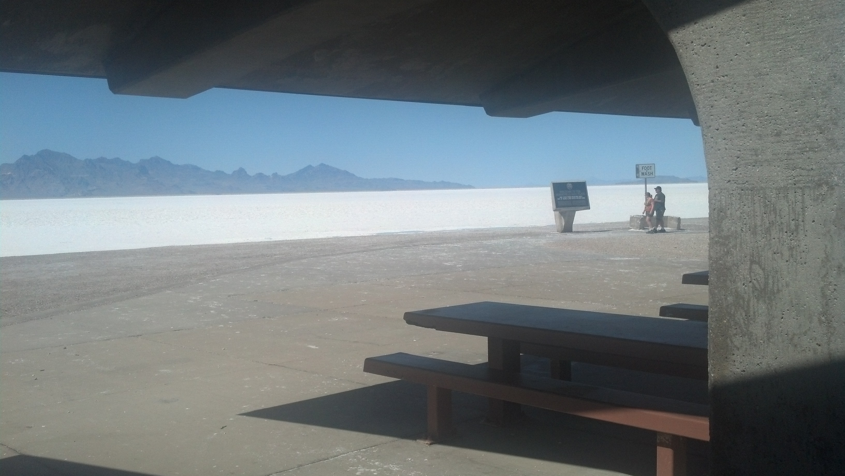
This is a lovely spot for a picnic, eh? (Photo by Michael E. Grass)
Later, I pulled off at a rest area a few miles from Wendover. It was time to stretch my legs. There was a carload of travelers here already but they soon left after I arrived.
The rest area’s sheltered picnic canopy was quite unusual, but seemingly appropriate for the wide white expanse of the salt flats on either side of the highway. It looked like some white-washed desert structure that would fit in well at the desolate settlement on Tatooine where Luke Skywalker grew up.
But who would want to have a picnic here? The wind was hot, blistering and dusty. I assumed that the inhospitable conditions out here persisted for most of the summer. The ground — and later, the floor mat in my rental car — was covered in white, chalky salt, originally deposited here when the ancient Lake Bonneville dried up and later, tracked up my car tires and human feet. I had a strange craving to salt-and-vinegar potato chips.
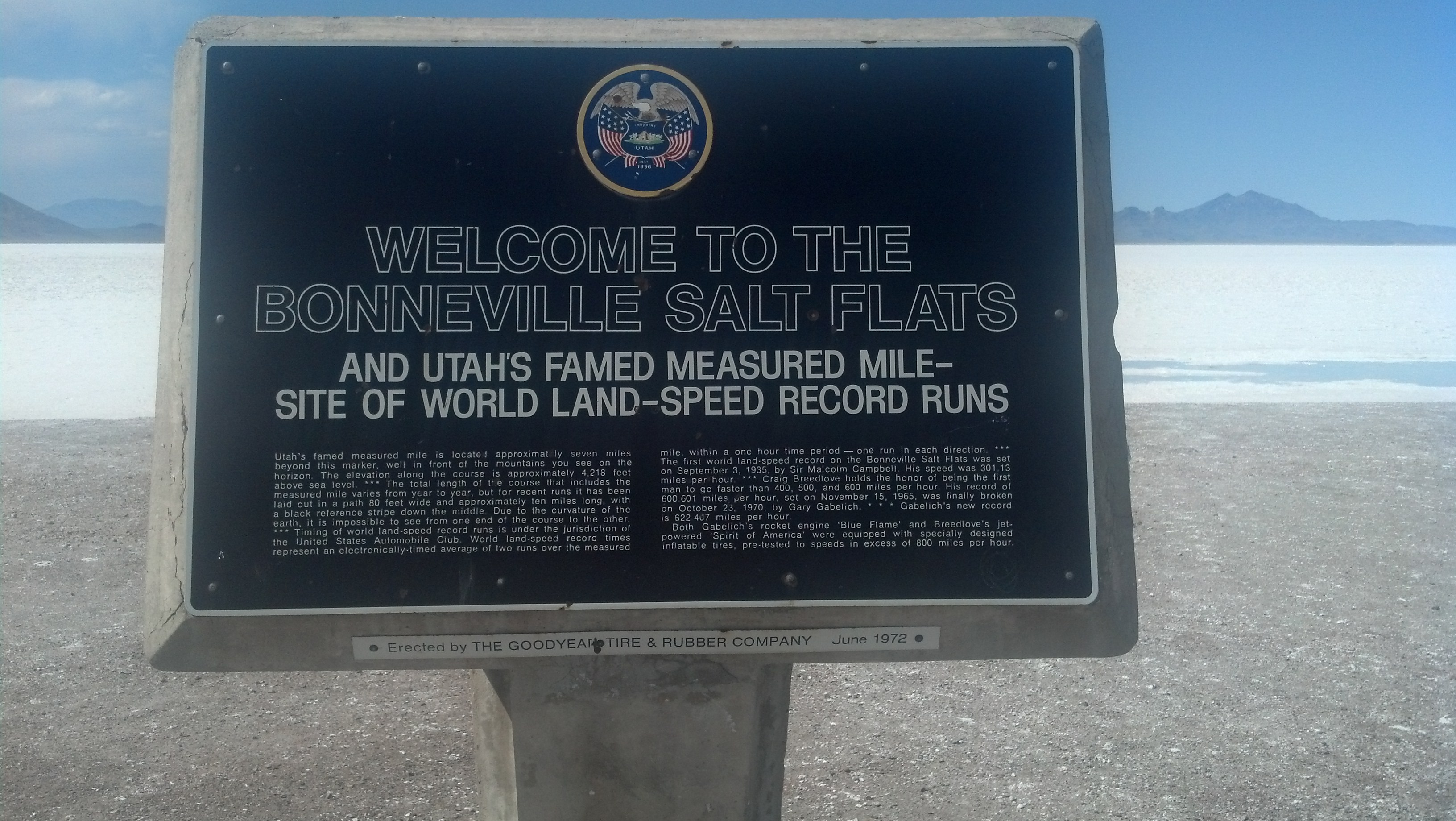
Seven miles beyond this sign, land-speed records have been broken. (Photo by Michael E. Grass)
A minivan pulled up and parked under the canopy, which provided some shade from the intense afternoon sun.
An Asian couple came out ushering two small children who seemed awfully confused where they were. The family initially milled about and inspected the sign marking Utah’s famous “measured mile,” a stretch of the salt flats seven miles beyond where land-speed records have been broken.
The father wandered off a few yards away and had trouble lighting a cigarette. It was too windy. He eventually gave up.
The family approached me to say hello. They asked me where I was from. They told me they came from Osaka, Japan. They asked me to take their photo with their Nikon. I naturally obliged.
When the photo session wrapped up, the mother asked me: “Have you seen the tornado?”
“Tornado?” I asked. “Here?”
“Yes, out in the desert,” she replied, pointing out toward nowhere in particular. (You could point in any direction and not miss the desert.)
She was referring the the dust devils that I had seen minutes earlier. “Yes, those are dust devils,” I said. “Not a tornado.”
“Dust devils,” she repeated. “OK, thank you!”
The father chimed in with a big laugh and declared: “This place is heel.”
I was initially confused. “Heel?”
“Yes, this place is heel.”
I was still stumped.
“This is where the devil lives. The devil? Lucifer?”
“Oh, Hell.” I spelled it out. “H-E-L-L.”
“Yes, Hell! This is Hell! Hell! Ha ha!”
The gentleman from Osaka seemed quite happy to be here in Hell. I can’t imagine what it’s like to come from such a dense urban environment like Osaka to a place as desolate and alien as the Bonneville Salt Flats.
It was strange for me as well. We might as well have been on the moon. Nevada was just a few miles away.
Where the hell am I? (Photo by Michael E. Grass)
Pingback: The Best Beach So Far This Year? | The Lincoln Highway Guide